 Last week's column explored some of the origins of the word Koronis and the past and present Indian legends attached to the name. This week territorial maps, the Cedar Lake connection, and the town/post office that shares the lake's name will be explored.
On early territorial maps developed by explorer Joseph Nicollet, Lake Koronis appears to be grouped with two other lakes and all were named "Crow Lakes." In 1857, the lake was identified as Cedar Lake. Minnesota became a state in 1858 and different map companies identified the lake as Cedar or Koronis.
The May 24, 1930, issue of the Daily Times presented their explanation of why Koronis was also known as Cedar Lake. In pioneer days "thousands of beautiful trees of this species lined the slopes of the lake. Many cedar fences in the vicinity of Paynesville, erected 50 years ago, are still in excellent condition and are the last vestiges of this crop of red cedar, once one of the best in the state."
In the summer of 1930, the Litchfield Independent also addressed the issue of the origination of the name "Koronis." The story read "The late James Nelson, who located in Union Grove in 1856 with the first white settler in the county, stated to the writer that so far as he could recall from the very first it was called Koronis by the settlers in the neighborhood.
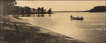
"It is easy to figure how it came to be named Cedar Island. The three islands in the lake, as well as the main land shores, were originally well-studded with red cedar trees. These have long since disappeared due to the demand by the settlers for this valuable wood for fence posts. In the original government survey about the lake the three islands were ignored by the surveying crew, doubtless because it would be considerable trouble to get them platted. This, of course, lead to their being considered common property by the settlers, and the timber was cut off in the winters.
"The Caswells at the first fourth of July celebration in 1875 at the old Manannah village a mile west of the present town, went up the river by boat and cut a tall cedar tree on one of the islands, floated it down the river and erected it as a "liberty pole" to carry a homemade flag. Later when the village was moved to the new location it was set up in front of the old hotel that still stands where it was originally erected."
Father Joseph D. Varley, Church of St. Louis, Paynesville, on Sept. 22, 1949, addresses some of the clues that he found in his research of the name, "Koronis." In his letter he writes, "In 1886, when the Great Northern built thru, a plat of a town was made around the depot here, and filed in the court house as 'Koronis.' Was the lake named from that? No, for definitely the lake was being called Koronis at that time. No doubt the village was named from the lake. The village that developed, however, was always known as Paynesville負hat name being taken from the Paynesville that existed from 1857 a few miles away."
Father Varley was referring to a plat of a town north of Paynesville that also had the name "Koronis." I have not found any further information on this town plat. Several years ago a gentleman came into the Paynesville Press office saying that he had this town on an abstract of his property. Unfortunately, I was unable to contact him and the connection was lost.
The most fascinating discovery for me was that a Koronis Post Office existed from 1868 to 1874. It was located in Union Grove Township in Meeker County, just south of Lake Koronis. On an 1869 map the lake was called Cedar and the town south of the lake was named Koronis. It is unclear if it was a town or just a post office. We can only surmise that the fate of the town/post office was directly tied to the decision of the railroad to build to the north. Without the mode of transportation provided by the railroad, many small towns disappeared.
A federal census in August 1870 gives us information about the people tied to the post office "Coronis." Ten families and ten dwellings made up the community. Twenty-three white males and seventeen white females were included in the census. Names from the census, some familiar and some not familiar, follow: Blevius, Brown, Hunter, Couch, Marshall, Black, Jebb, Nutting, Orin, Beaumout, and Castle. Of the men in the census eight were foreign born, from countries of England, Scotland, Canada, Switzerland, and Norway. Six females were also foreign born, from countries of England, Scotland, Canada, and Norway. Twelve children were of school age; however, only three had attended school within the year. The youngest inhabitant of the area was seven months old and the oldest was seventy years old. The men's occupations were all listed as farmer and the women's occupations were listed as "keeping house." The value of real estate ranged from $100.00 to $1500.00. The values of their personal estate ranged from $200.00 to $550.00.
As of today no clear answer exists regarding why the lake was named Koronis. All of the information gathered from the similarly named asteroid and Boeotian princess, to the Latin and Greek word connections, to the Indian legends, to the history presented in maps and federal census leaves us with the same question: "Why was the lake named Koronis?" Someday further information may be found but in the meantime the lack of a clear answer will not deter us from enjoying a view from the lake.
Archived View of the Lake articles