View from the Lake
Road disagreements led to arrests
 Last week's column presented a controversy present in 1891 regarding establishment of a road leading south of Paynesville to Lake Koronis. By 1892 another problem related to a second road to the lake had arisen and caused hard feelings between those people wanting better access to Koronis Park and one particular landowner.
Paynesville as a town was changing. The locations of two main railroads, the Great Northern and the Soo Line, split the town; some businesses, including the Press, migrated toward New Paynesville. Many of the business owners in New Paynesville were the same people who were developing Koronis Park by the lake. They desired a road to the east of the original road leading to the "Old Landing" on Koronis.
In the late 1800s, the law allowed for a road on a section line when a number of landowners requested the road. In June 1892 "After the petition was properly posted, about thirty men went down and cut the brush out, about 25 or 30 feet wide along the proposed road." All landowners along the petitioned road had agreed except for one, Mr. Arndt. He owned only ten acres.
A warrant for the arrest of George Stephens, editor of the Paynesville/New Paynesville Press, Professor Angus Haines, and Bert Haines was issued. The constable arrested Angus and Bert Haines; Stephens was out of town. The charge was malicious trespassing on and damaging a landowner's timber to the amount of $50 from the opening of a cartway on the section line leading to the lake.
The complaint appeared to be filed by someone other than Mr. Arndt. "It is said that the man bringing the suit does not own the ten acres. Putting these things together it looks like spite work and he is not at the bottom of it either. Other parties have been heard to gloat over the possibility of a lot of east enders being arrested and fined." East enders refers to those living in New Paynesville.
The Press reported that the damage to Arndt's land was minimal. "If the road were cleared out the full width, it would take only one-half acre of his land. Estimating it at $10 per acre, his loss would be $5. When all the other owners of far more land, were willing to have the road, and even said they would ask no damage, his actions look like that of a surly dog."
"We propose to be there (at the trial) and learn why three persons were picked out of thirty, and a full report of the whole dirty, malicious, unkind, unchristian affair will be made. The dog in the manger would neither eat hay nor let others eat, so these fellows will neither put a road to the lake or let anyone else do so. The sight of push and enterprise makes them mad. The moss is so thick on their backs you could comb it with a hayfork. They are flies on the wheels of progress, rust on the axle of the band wagon, cranks and hypocrites who profess to be followers of the Genius of Galilee. . ."
At the trial County Attorney Taylor appeared for the prosecution and Frank Tolman was the defense attorney. "...though there was absolutely no need of there being any defense, for the case was all decided before court commenced, and the trial was only a matter of form, thin as rail soup and twice as foolish."
"Old Mr. Arndt was then called and sworn. It was claimed that he could not understand English, so J. E. Holtz was secured as an interpreter, but it was somewhat smilable when the old gentleman sometimes replied direct in pretty fair English. He began by saying that he owned the ten acres that was so terrible damaged by cutting a few popple poles from it. . .The old gentleman said it was brush land but by some careful questioning he was induced to change it to timber land. He hadn't seen it for six months, until he went down to see it after the brush was cut that damaged it so. He said that part of the cut trees were taken away. This could easily have been proven untrue, if a chance had been given. He said a strip 12 feet wide was cut along the east side of his ten acres, and amounted to 300 or 400 popple trees, which he estimated by those standing on the side."
Other people were called to testify, but no one seemed able to identify all the people present that day that the land was cleared. Finally, the prosecution's attorney told the court he would be satisfied "to have the defendants bound over in the sum of $100 each to appear before the district court next December."
Interestingly, no mention was made in the proceedings of anyone being able to identify Angus or Bert Haines actually cutting one stick. In fact, not one of the witnesses could place Bert Haines at the scene.
"Our statement of last week is borne out that it is a piece of dirty spite-work. No one need to tell us that the simple-minded old man could or would plan such a careful scheme of blackmail and robbery. It is clearly a case of bluff, and persons have been heard to say that the $50 was to be divided up between the ring-leaders. . .Several of them came around and tried to get the defendants to pay something to settle. In other words they wanted to be bought off. It showed they had no case, but they wanted money."
The split between Paynesville and New Paynesville fueled the fire regarding the new road. Some wanted change and new opportunities and others wanted stability and were content with what existed. Even with a trial that seemed one-sided, the progress in creating better access to Koronis could not be stopped.
By August the controversy subsided and the "Supervisors made the order last Saturday, laying the new road to Lake Koronis, touching at the Park. It is a good line, lying quite nicely, and with a small amount of work, will be by far the best route to the new boat-house and landing." As all of us travel around and to Lake Koronis pause and think of the many people who forged the way, clearing brush, and starting controversy, on their way to a view from the lake.
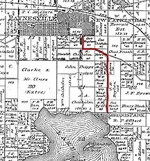
Information was taken from the following issues of the Paynesville Press: June 16, 1892; June 23, 1892; August 4, 1892. The Plat Map was issued in 1896 and can be viewed at the Paynesville Historical Museum.
Contact the author at paypress@lkdllink.net • Return to Viewpoint
Home | Marketplace | Community