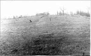
The Indian Mound on the Behr farm south of Lake Koronis.
Last week this column was about Philip Behr's belief that Dakota Indians migrated from the Mankato area to Lake Koronis for hunting and fishing, while camping on his farm's ten-acre field. He believed that this migration occurred over and over prior to the exploration of the European explorers. On this same farmland is located "The Indian Mound." Over the years I had heard about the mound, but it wasn't until I met Behr and his daughter, Mary Hahn, that I began to understand the history involved in this land.
An article originally printed in the Minneapolis Times was reprinted in the New Paynesville Press in January 1895. Most of the article spoke to the beauty of Lake Koronis, but it also talked of the Indian Mound. "One of the peaks of land near the outlet of this lake is distinguished as the second highest Indian mound in North America. It is now 119 feet high, made of gravel from the lake shore, formed into a hill. . . Everything about this lake looks just as it did 100 years ago...but the Indians have departed, and all that is left to mark their one time presence consists in the winding trails that curve in and out among the trees, which although some of them were made 100 years ago, time has yet failed to efface."
In the July 28, 1899 issue of the New Paynesville Press Dr. H. C. Watson of New Paynesville was reported to make some interesting discoveries at the Indian Mound. He had become very interested in gathering and unearthing Indian relics of various kinds. At one time he found an Indian hammer which weighed about ten pounds. "He also has dug up an Indian skeleton from the mound we are informed and is expecting a party of friends from Duluth shortly to explore the mound thoroughly. The work will require about three weeks of time."
When European explorers identified this area, they referred to the mound as "bare hill." On one side of the hill, perhaps because of human traffic up and down that side, the hill was bare from trees. Later, settlers came and began to farm the land. At this time a bear had dug a den in the top of the hill. Thus, people began to refer to the mound as "bear hill." Finally, to complete the trilogy, Charlie Behr (Philip's father) bought the farm which included the mound. People continued to refer to the hill as "Behr hill." I mistakenly believed that the Indian Mound was a burial place used by the Dakota Indians in the past few hundred years. However, according to archeologists over the years, the Mound dates back to prehistoric times.
Several years ago, Nancy Slator reported about the Koronis Indian Mound being the third largest in Minnesota. Archeologist Scott Anfinson went to Paynesville in the late 1930s to investigate the effect the highway relocation would have on the Indian mounds in the area. Several mounds existed from the southern tip of Koronis and across the Crow River outlet. He believed that the largest mound, east of the outlet, towered over an Indian village located on the edge of the lake. The village was most likely occupied on and off for about five thousand years. Anfinson was unsure why the mound was as large as it is. Perhaps, a more important chief was buried in the mound. He believed that the mounds in the area were built between the years 500 and 1500 A.D. by Dakota Indians. "Usually burials are in the vicinity of a village, but not right in it. Most villages are of course near water. A lot of mound groups don't have to be (near water) but are because they're near the village."
On June 17, 1993 two archeologists visited the Indian Mound. One of the archeologists was Guy Gibbon, head of the Department of Anthropology at the University. He believes the Indian Mound to be of the Havana Culture which existed between 100 B.C. and A.D. 200. "In general, the larger the mound, the older the cultural period represented. Burials were under the ground with sod and topsoil laid aside, the grave was dug, burial made, topsoil and sod were replaced, and then the mound was built to represent mountains or some element of mother earth. The mound soil was from a village, not just any soil scooped up from a surrounding area. "
In the 1911 Aborigines of Minnesota, a report based on the collections of Jacob V. Brower, and on the field surveys and notes of Alfred J. Hill and Theodore H. Lewis, published by the Minnesota Historical Society, the mounds at Lake Koronis are described. Location of the mounds is outlined in detail as well as size of the mounds. Anyone interested in geographic detail can find this report, including maps, at the Paynesville Historical Society.
No one has ever fully explored the Indian Mound, nor will they ever. Hahn, who now owns the land, plans to place it under the Minnesota Land Trust. This trust will establish permanent land use restrictions and "promote the protection and enhancement of open space." She has and continues to spend countless hours restoring the land. Philip Behr told me that he believed history comes full circle. Now, after thousands of years of use, the land supporting the Indian Mound is returned to nature, allowing for future generations a historic view from the lake.
Note: On display in the Paynesville Historical Society are pieces of pottery, found on Behr's land, that date back to pre-history times. Also, anyone interested in viewing Philip Behr's story (recorded in 1991) may do so at the Paynesville Historical Society.