Behr's belief is that Dakota Indians from the Mankato area
migrated each spring to Lake Koronis to hunt and fish.
Behr's belief is that Dakota Indians from the Mankato area
migrated each spring to Lake Koronis to hunt and fish.
On the south end of Lake Koronis stands a 100-foot glacier hill that has been the mixed source of story and history. No one will ever know the entire truth, but an attempt will be made to separate some fact from fiction.
Two summers ago I had the privilege of interviewing Philip Behr, a long-time resident of the area, retired farmer, and retired St. Cloud State instructor in geography. Unfortunately, with his death last summer, a portion of Paynesville history also died.
As a farmer, whose land touched the southeast shore of Lake Koronis, Behr plowed a 10 to12-acre field located between the lake and the large glacier hill. Over the years he hauled hundreds of stones, all of which had been cracked from heat, as shown on their sharp edges. Natural stones are polished as they have been rolled and worked over by the glaciers. Behr believed that Indians came to Koronis in the early summer and camped on this field. They fished and hunted and then dried the meat over the campfires on the level land. The dried meat was then brought back to the Mankato area for their winter food.
Indian artifacts, including arrows, stone mauls, knives, and pottery have been found over the years on this property. Many of these artifacts are on display at the Paynesville Historical Society.
Behr contended that the Indians were of the Dakota tribe and spent the winter in the Minnesota River Valley near Mankato. Each springtime they sent one group of their tribe to Lake Koronis via the Crow River. They canoed up the river as the entire country was wooded and river travel was the most efficient. Year after year the Indians returned to Koronis, to the camp in the 10-acre level field near the lake.
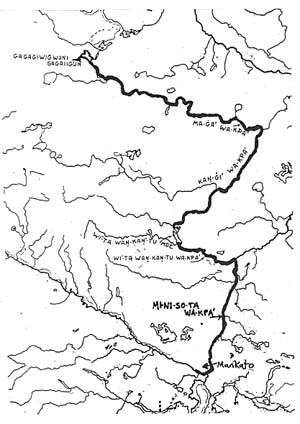
Looking at current maps of the geography of the area, it appears impossible for anyone to canoe from Mankato to Koronis. Paul Durand, author of Where the Waters Gather and The Rivers Meet spent years gathering information about Indian names and meaning of historic Indian sites/locations in the Midwest. Using his map it becomes possible to trace waterways from Mankato to Koronis. The route the Indians might have taken began near Mankato where they canoed north on the Minnesota River (MI-NI-SO-TA WA-KPA'). They reached a navigable stream where it was possible to portage from High Island Lake (WI'-TA WAN-KAN-TU MDE) to the south branch of the Crow River (KAN-GI WA-KPA'). The south branch eventually connected to the north branch of the Crow River (MA-GA' WA-KPA') which was also known as Gose River. The north branch led the Indians to Lake Koronis (GAGAGIWIGWUNI SAGAIIGUN which meant Raven Feather Lake).
In meeting with Durand and presenting Behr's hypothesis, Durand believed it was feasible for seasonal migration to the benign climes of the MA-KA-TO (present day Mankato). However, "It must have occurred prior to the Mille Lacs debacle of about 1745 or so. The Koronis area was a contested zone between these two tribes for many years and hunting groups never entered unless prepared for war."
Eventually, white explorers and hunters discovered Lake Koronis. Behr believed that they too camped in the 10-acre field and reaped the bounty of fish and wildlife. Again, their major access to Koronis was by canoe and waterways.
As settlers moved into the area in the 1800s, railroads became a major source of transportation. The area was settled, farming became a major occupation, and the hunters and explorers became a part of history. As one stands near that 10-acre field on the outlet bridge looking toward massive Koronis, it is easy to understand why human beings have always been drawn to a view from the lake.
Note about Durand's map: Durand's orginal map contains hundreds of Indian sites. All of the meanings are outlined in his book. For clarity, I have erased all the other sites. Anyone interested in Indian History would find his book intriguing. "Where the Waters Gather and the Rivers Meet" may be obtained from Paul Durand, 15341 Red Oaks Road SE, Prior Lake MN 55372 ($14.95 plus $2 shipping and handling.
Acknowledgement: Dorothy Hend- rickson approached me in June of 1994 and told me I needed to talk to Philip Behr about the Indian mound. I was fortunate to be able to talk to him. My only regret is that I was unable to finish these columns before his death. His daughter, Mary Hahn, has been another wonderful source of information and I am grateful to her for her assistance.