 �I have worked the farm 20 years fighting run-off from the fields,� Terry Schaefer said. �Dad purchased the farm in 1946 and had the same problems.�
Through his work on the Roseville Township Board, Schaefer has heard discussion on how a pond upstream could help control flooding downstream at the North Fork Crow River, Rice Lake, and Lake Koronis.
Schaefer started the planning process last February for a flood control sediment basin on his farm, west of Paynesville.
Schaefer met with Mike Mayer of the Stearns County Soil and Water Service to learn more about the various programs and receive help to design the project.
Looking at the pasture where the sediment basin was to be erected, a person doesn�t see the stream which can contribute flooding downstream or how the pasture can help prevent a flood.
In researching the project, Schaefer discovered he had a DNR protected stream running through his pasture. Snow melt and rainfall, from an 800 to 900-acre watershed, feeds into this stream from neighboring fields and waterways.
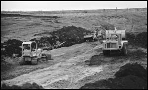
The sediment basin is being created by building a dike 65 feet wide, 290 feet long, and 13 feet high across a section of Schaefer�s pasture. �What we�re basically doing is joining two hills together,� Schaefer said.
An 18-inch trickle tube will be installed at the base of the dike to help klep the water flowing at a fixed volume and to slowly empty the basin. An emergency spillway will be installed near the top to create an added exit for when the water flow is high, following a heavy rainfall or snow melt in the spring.
Clay from the top of the pasture slope was being utilized to help create the dike for the basin. The dike will require about 3,000 yards of clay. Field rocks which have been piled up along the edge of the pasture over the years, will also be used as rip rap to reinforce and cover the banks of the basin.
�I won�t lose much pasture because of the sediment basin,� Schaefer said. �When the water is at its highest point, it will cover about six acres. When the water is at its lowest point, there should be about an acre covered in the pasture.�
Schaefer said he plans on fencing off the basin so the cattle won�t erode the banks of the dike.
In surveying the land for the sediment basin, Schaefer found that from the north end of his pasture to where the dike is located, the elevation drops about 20 feet. �Water will always find its correct level,� he added.
The project is being funded on a cost share basis by Schaefer and through the Environmental Quality Incentive Program, Koronis Lake Association, North Fork Crow River Watershed District and the Kandiyohi County Water Plan.