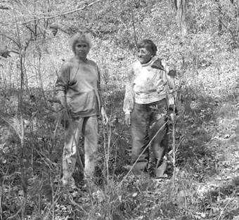
Evelyn Moore, left, stands in the groove of an early ox cart trail
that crossed her property. Dolores Hislop is on right.
There were several trails crossing Minnesota. Although there were no major trails in the Paynesville area, there were many trails crossing the state to the north of town. The woods trail traveled north from St. Cloud to Crow Wing; the middle trail was also known as the St. Cloud trail which consisted of several branches from St. Cloud to Richmond, or Sauk Centre. In 1869 the branches were known as the Stage Road, Old Middle Trail and Middle Trail. The middle trail followed Highway 23 from St. Cloud to Richmond then headed westerly to Lake Henry and George Lake. The easier trails followed the curve of the Sauk River through New Munich to Richmond. At Richmond, the old Middle Trail joined the stage road.
St. Cloud was for many years, the outfitting point for the country to the north and west. Norman Kittson employed many fur traders. He started out with six ox carts, in the next seven years the number grew to 102 and by 1858 to 600. According to the History of Stearns County, caravan carts presented a unique spectacle and one which in all probability will never again be seen on this continent.
The St. Cloud Times printed an article in March 21, 1949, where Glanville Smith described one of the Red River trail routes taken by pioneers� �The trail proceeded from St. Cloud from the mouth of the Sauk to St. Joseph via the site of the future veteran�s hospital and so to Cold Spring on the route of the present county road. At Cold Spring it was headed due south, its location still marked by Red River Street, the street that comes down hill past the brewery. South of Cold Spring, at the present Knaus bridge, the trail turned west, in a couple of miles joining the current route of Highway 23 into Richmond. At Richmond the Sauk was forded, a short distance above the railway bridge of nowadays. The trail then followed the present St. Martin road for three miles, cut west via a still-in-use side road, then proceeded by an easy diagonal over the open lands that lay to the northwest.
�The gridiron road system of Zion, Lake Henry, Spring Hill, Lake George and North Fork Townships retain scant traces of the trail, though here and there a nonstraight line still shows in the plat books.�
The Red River ox cart looked like a ramshackle, squeaky affair to anyone unacquainted with its virtues. In the book History of the Trails, one observer noted, �Each cart, waggles its own individual waggle, graceless and shaky, on the uneven ground.�
The carts were designed for the wide variety of travel conditions. The cart was easy to draw through bogs, buoyant at river fords, strong on rock-strewn hills and hard to upset in stumpy forests. The body was made of tough, well-seasoned oak. Although the particulars of construction varied with each cartmaker, most builders started with two squared 12-foot poles. Six feet of their lengths served as the shafts for harnessing the ox, while the other six feet supported the frame of the cart. Crosspieces were firmly mortised into the shafts to underlay the floor, and upright rails were fitted into poles. Front, side, and tailboards to hold the load completed the carts body.
The five-foot high wheels were the most unusual feature. To lend stability to the vehicle, they were dished outward so radically it looked as if the outer rims were about to part company with the spokes and hub.
The cart was not only sturdy, it was also versatile. At night the buffalo-hide or canvas cover could be thrown over the cart, making a compact tent for the driver, who had no need to carry tent poles or pins. The carts could also be converted into makeshift boat or raft to cross rivers. The sound of the ungreased wooden wheel rubbing against the wooden axel could be heard three miles away.
Ox cart trails could be identified by three parallel grooves carved into the endless miles of prairie. Two furrows were made by the wheels of the carts; the third, cut less deeply, by the hooves of the patient beasts which drew the carts.
Trail crosses farm
Evelyn Moore, rural Paynesville, has an ox cart trail crossing her property. She heard stories from her father, Theodore Foreman, that farmers used the trail to take grain to the mills at Grove City where they had flour made. �We first found the trail 24 years ago. Twenty years ago when there were cattle in the pasture, the ravine made by the ox cart trails was very noticeable,� Moore said. �Today the tall grass makes the trail harder to find. However, where the carts once traveled, the area is clear of trees and brush.� The area where the ox cart trail is located is in the center of 18 acres of woods.
Previous Article
Next Article
[ Return to Previous Menu | Archived Press Stories Menu | Return to the News Page ]