MnDOT announces west route as 'preferred alternative'
Project manager Lowell Flaten quickly announced the west route as the choice of the Minnesota Department of Transportation (MnDOT) and the Federal Highway Administration as the "preferred alternative," or future route, of Highway 23 in three minutes at a task force meeting at the Paynesville Area Center on Wednesday, Sept. 21. Map of West Route
Two dozen local residents attended the meeting, along with ten task force members. The meeting lasted for a half hour, a short one for the task force, and the decision to pick the west alternative lasted only a few minutes.
 Flaten - who works for MnDOT at their district office in Willmar, which is coordinating this project - said there were four viable options studied in this project (improving the thru-town route, the east route, the far west route, and the west route). All these would have served the traveling public, Flaten said at the meeting.
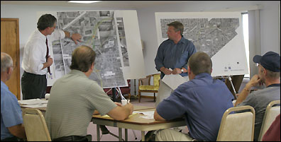
Engineers Tom Parker (left) of Edwards and Kelcey and Lowell Flaten (right) of MnDOT explain some changes to the proposed west route at the Highway 23 task force meeting on Wednesday, Sept. 21, as city administrator Steve Helget and mayor Jeff Thompson listen.
The decision to pick was heavily influenced by Highway 23's consitutional designation to serve Paynesville and the support of the Paynesville City Council for the west alternative.
"The west should come as no real surprise," said Flaten. "It's the one that the city unanimously supported."
"We put a lot of weight on the input of the city," he continued. "We felt it met the needs of the traveling public as well as the city and the surrounding area."
MnDOT and its consulting engineers from Edwards and Kelcey will now focus on completing the final Environmental Impact Statement (EIS), which will identify the west route as the "preferred alternative." The main task is to address comments raised following the publication of the draft EIS in June.
Now, having selected the route, said Tom Parker, the lead engineer for this project with Edwards and Kelcey, all efforts will be focused on the west alternative. That means they will be addressing comments and concerns about the west route only. "Everything is going to be focused on the comments as they address the west alternative," said Parker.
Parker said they hope to have the final EIS done sometime this fall or winter. The final EIS will also be subject to a written comment period but will not have an open house for public comments.
The final step is for the Federal Highway Administration to issue a record of decision, expected sometime in 2006.
Even before that, said Flaten, in the spring of 2006, MnDOT expects to start right-of-way acquisition for the new route. MnDOT will need about 300 feet of right of way for the new four-lane highway, he added. Right-of-way acquisition by MnDOT will be done in a similar manner to how the property was acquired for the new airport. First, MnDOT will verify ownership and then have affected parcels appraised. Property owners can then have another appraisal done on their property. Flaten described right-of-way acquisition as a lengthy process.
For the new airport, eminent domain was needed to acquire the necessary property.
The Highway 23 project in Paynesville includes improvements just in the immediate vicinity; Highway 23 will remain a two-lane road by Hawick and by Roscoe even once this project is completed.
The Paynesville project received $7.1 million in federal funding as a high-priority project in the recent highway bill. This appropriation has led MnDOT to schedule the project for 2009.
Flaten noted that MnDOT estimates the total project cost at $32 million. While the EIS will include a full build-out - the maximum impact on the environment, including all possible interchanges - the construction plans for 2009 will be scaled back slightly. "There's a difference," said Flaten, "between the full build, which is what will be in the EIS, and what will be proposed to build in 2009."
Within the next three months, Flaten expects construction plans to be brought to the Paynesville City Council for municipal consent. Because Highway 23 is constitutionally designated to serve Paynesville, major changes must be approved by the city council.
Currently, the design speed for the west alternative is for 70-mph driving, said Parker.
The bulk of last week's task force meeting actually centered around new details about the west route. Changes to the proposed new highway, from west to east, include:
*Redesigning the interchange at Roseville Road. While this will be drawn as an interchange in the EIS, which must show all long-range impacts, MnDOT only plans to have an at-grade intersection here in 2009.
*Realigning Cemetery Road. Cemetery Road, or Main Street, which runs east-west past the municipal liquor store and then the Paynesville Area Center and out to the Paynesville Cemetery, would be shifted to the south by about a block. Instead of coming out at the liquor store, the realigned Cemetery Road would go over the new highway and then intersection with the old highway across from the north access to Paynesville Area High School.
*Shifting the new highway about a block to the west, following the runway of the old airport, before crossing the North Fork of the Crow River. This should affect fewer houses, the task force was told. The west alternative now would roughly follow Liberty Street.
*The interchange design for Lake Avenue has been changed. MnDOT plans only to build an at-grade intersection here in 2009, the task force was told, but the interchange design is included in the long-term plan.
*Adding a bridge over the new highway to connect Co. Rd. 33 with the old highway. In past designs, Co. Rd. 33 would have been cutoff by the new highway.
A number of comments to the draft EIS cited a lack of access to north of town, including by first responders. They noted that Co. Rd. 33 is a prime route to the north because it does not cross a railroad track; emergency vehicles, rather than risking a delay at the railroad tracks, go out instead on the current Highway 23 and then north on Co. Rd. 33. Building a bridge for Co. Rd. 33 would maintain this connection.
Co. Rd. 130, another access to the north, would need to be realigned due to the west route of Highway 23 but would stay open to traffic heading north of town. Lake Avenue to 185th Street would also continue to be an option, though this traffic would have to stop for the new highway at the at-grade intersection currently planned.
Contact the author at editor@paynesvillepress.com • Return to News Menu
Home | Marketplace | Community