Public hearing on Highway 23 scheduled for Tuesday
This event will start with an unofficial question-and-answer open house with MnDOT personnel and Edwards and Kelcey engineers at 5:30 p.m. These discussions will not be recorded for the official record.
 At 7 p.m., a formal presentation will be given about the draft EIS, to be followed by a public comment period. This official comment period is intended for public input, not to ask questions of MnDOT personnel or the consulting staff.
Five alternatives are studied in the 100-page draft EIS: no build, improving the thru-town route, and three bypass routes (east, far west, and west). MnDOT and their consulting engineers at Edwards and Kelcey, though, have concluded that the document does not support choosing a "preferred alternative" yet, and all five of these alternatives are presented in the draft EIS.
MnDOT plans to use official comments - along with the information gathered in the draft EIS - to determine the "preferred alternative" later this summer, following the close of the official 45-day comment period on Monday, July 18.
Copies of the draft EIS are now available locally for public viewing at Paynesville City Hall and at the Paynesville Public Library. (These copies are available for on-site viewing only and are not available for check out.)
The public will also be able to send written comments to: Lowell Flaten, MnDOT - District 8 Project Manager; 2505 Transportation Road; Willmar, MN 56201-0768. His fax number is 320-231-5168. Also, next Tuesday night, a court reporter will be available at the auditorium to take one-on-one comments from people who do not wish to speak at the public hearing. And comment cards will be distributed. These can be returned by mail with comments.
The following is a brief synopsis of some of the key areas of the draft EIS.
Purpose and Need
The need for improvements was documented in a 1997 study: "Issues in PaynesvilleŠalso reflect a relatively high need for implementing improvements. Geometric and access problems, along with limited lane capacity, combine to create potential capacity (level of service) concerns in the future."
Geometric problems, as identified in 1997, include the undesirable angle of intersection with Highway 55; a 13-degree curve at Belmont Street/Wendell Avenue; an 18-degree curve at Central Avenue; the narrow railroad underpass; the curve by the golf course; and the lack of passing lanes northeast of Paynesville.
Access issues include the number of driveways and side streets connecting to Highway 23, as well as Highway 55 and the former Highway 124.
The study indicates that while the current alignment handled traffic satisfactorily in 2001, it will not by 2025, based on traffic projections.
Highway 23 "is classified as a Medium-Priority Interregional Corridor" from Interstate 90 (in southwestern Minnesota) to Interstate 25 (north of the Twin Cities). Currently, 40 to 55 percent of the traffic on Highway 23 in Paynesville is thru-traffic. On summer weekends, this percentage increases to a range of 70 to 85 percent of thru-traffic.
"A primary goal of an (interregional corridor) is to maintain target speed. Signals are an impediment to speed." Without a project, the likelihood of more traffic signals on Highway 23 increases.
"Improvements to (Highway 23) in the Paynesville area will assist in meeting the regional mobility requirements of this interregional corridor. A bypass alternative will further enhance the overall performance from Willmar to I-94."
 Raised Issues
The study lists the following issues as having been raised so far:
*Concern over the loss of business to downtown district and overall community, primarily but not exclusively with the far west bypass.
*Access to a Jennie-O farm is severed by the east/west alignment.
*Access to the city for some rural residents would be rerouted with the closure of the intersection with Township Road 276.
*Noise impacts from current residents along the highway.
*Impacts to the golf course by the east bypass, leaving the options of redesign or closure.
*A Mesic Prairie, a site of moderate biodiversity, lies near the proposed rerouting of an intersection with Highway 55 for the west bypass.
*Concern by local officials, business owners, and residents about the timely selection of a "preferred alternative," or future route of Highway 23.
Environmental Consequences
The draft EIS studies a number of environmental consequences and potential mitigation measures for the five proposed options, including:
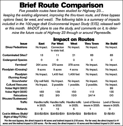
*Bikes and pedestrians - the only potential consequence is the far west crossing the Glacial Lakes Trail. But the study says the trail could be rerouted with the new highway to have a better crossing of the Canadian Pacific Railroad.
A longer crossing for pedestrians if the thru-town route was widened to four lanes was considered mitigated since the road would have a center median, enabling pedestrians to cross the road in two movements.
*Businesses and local economy - the study acknowledges that some businesses would be impacted by a relocation of the highway, especially those that "supply automobile-oriented services, namely gas stations and convenience stores."
"Of the 15 to 30 percent of the through travelers who do stop in Paynesville, all but a small percentage stop for only food or gas."
"Some highway-oriented businesses will likely relocate or modify their businesses to avoid losses, while others may decide to cease operation. However, overall community business activity is not expected to be significantly altered."
Improving the thru-town route - widening it to four lanes - would require the relocation of nine business in the downtown area and by the intersection of Highway 23 and Highway 55. (That intersection would be reconfigured to be more perpendicular.)
*Relocations - Improving the thru-town route would also affect the most residential relocations (24), followed by the west bypass (15), east bypass (8), and far west (3).
*Noise - Testing for noise at existing traffic levels and then modeling future noise impacts based on traffic projections yields estimates for noise impacts for the various routes.
In 2002, along the current route, 24 residences had noise levels above state standards during the day and 89 had high noise levels at night.
In 2025, based on projections, the number of residences with noise impacts at night, by route, were: east bypass (183), west bypass (150), far west bypass (139), no build (135), and improving the thru-town (113). Daytime noise impacts were: no build (52), improving the thru-town (32), east bypass (6), west bypass (4), and far west bypass (139).
The study also concludes that using noise barriers for the east bypass to lessen the noise impacts at night is not practical from a cost/benefit standpoint.
*Wetlands - Nine wetlands would be impacted by the far west route; seven by the west; seven by the east; and one by improving thru town. In acres, wetland impact is: far west (12.14 acres); west (6.39 acres); east (2.4 acres); and thru-town (1.0 acres).
However, the study also indicates potential sites to create replacement wetlands in the area, identifying five potential locations.
*Floodplain - The far west (nine acres) and the east (nine acres) have the most direct impact on the floodplain of the Crow River (with the west at four acres), but the far west and west also have a longitudinal crossing (1,400 feet in length) of the Crow River.
*Groundwater - The east bypass would pass closest to the city wells.
*Parks and Recreation - Improving the thru-town route would mean paving the veterans memorial in a triangular park across from Grace United Methodist Church, but this 0.07-acre park could be replaced with a remnant parcel by Belmont Street (0.12 acres in size).
The golf course and driving range would be affected by the east bypass. This route would take the second hole and the driving range, "effectively eliminating its use as a driving range." To mitigate the loss of the second hole, the study states: "Preliminary analysis shows additional open space may be present to the east of the existing course and driving range."
*Threatened and Endangered Species - Wildlife and plants identified as potentially impacted include bald eagles (though no nests were located along the proposed routes); Dakota skippers butterflies; Small White Lady's Slipper; marbled godwit and Wilson's phalarope (sighted near the city sewer ponds); and mussels in the Crow River (no threatened or endangered species of mussels were found in a DNR survey).
*Farmland - Of the bypass routes, the west would affect the most farmland (261 acres directly, 18 indirectly, 279 acres total); followed by the far west (229 directly, 41 indirectly, 270 total); and the east (218 directly, 46 indirectly, 264 total).
Contact the author at editor@paynesvillepress.com • Return to News Menu
Home | Marketplace | Community