Five highway options to be studied in EIS
 Five options for Highway 23 in Paynesville will be studied in an Environmental Impact Statement (EIS) in the next year.
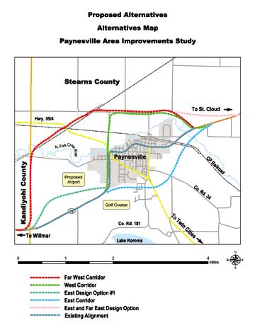
 The scoping document, which frames what routes should be considered in the EIS, has identified five options for study.
The routes to be studied, described from west to east, are: keeping the existing route without improvements; improving the existing route through town; bypassing town to the south and east; staying on roughly the same route until the river and then heading north of town; and leaving the current highway along the county line and heading west and north of town.
The technical advisory committee and the local task force agreed with Edwards and Kelcey -Ęthe engineering firm conducting the two-year study of Highway 23 for the Minne-sota Department of Transportation (MnDOT) - that only these five routes should be studied.
Three additional bypasses to the north of Paynesville had also been proposed: one following the railroad from Roscoe to Hawick, another cutting across Zion Township, and a third following Co. Rd. 16 from Roscoe towards Lake Henry and then south to Highway 23 again.
These options were judged to be too long and too costly. "It would be very hard to justify that 10 or 12 miles of extra road," said MnDOT engineer Lowell Flaten last week at a task force meeting.
Instead, only four "build" options will be studied, as well as keeping the highway "as is," which always must be considered.
Highway 23 in Paynesville was identified as having traffic problems by a 1997 MnDOT study. The current study will look at possible future routes and identify the best option for Highway 23 at the conclusion of the EIS.
Actual construction on Highway 23 in Paynesville is neither planned nor budgeted at present.
Since Highway 23 has been identified as an interregional corridor, MnDOT's goal is to move traffic through Paynesville faster and more efficiently. This means, fewer access points to Highway 23 and higher speeds. Ideally, there would be one access to the highway per mile, according to Tom Parker of Edwards and Kelcey, the project manager for the Paynesville study.
The high school/middle school complex, for example, currently has two accesses to Highway 23, but it may not keep them if the highway would continue to run where it does. "It may stay as two," said Parker. "It may go to one. It may go to zero. It depends on what works better for the school and for the highway."
In town, MnDOT would look at consolidating a number of driveways and streets to major access points. "It wouldn't be like it is today," Parker explained. "The access points, there are just too many of them."
Edwards and Kelcey has already done preliminary studies on keeping the existing route of Highway 23 through Paynesville, according to Parker, and projected the traffic patterns to 2025. With only two lanes through town, it will be gridlock, he said. With three lanes (adding a center turning lane throughout town), it's a little better but still not adequate, he said.
Edwards and Kelcey still has to look at making the road four or five lanes through Paynesville. This is "essentially making it bigger and bigger to handle more traffic," said Parker. "But in doing that, it affects the city of Paynesville."
Access could also be an issue in the country. Edwards and Kelcey have identified 23 driveways onto Highway 23 from the high school to the county line west of town, also more than ideal.
The current project will not look at the making Highway 23 four lanes from St. Cloud to Willmar. The four-lane road will stop in Richmond and New London.
At the meeting last week, task force member Jeff Bertram said MnDOT needs to plan for four lane in the Paynesville area, especially since the expansion of the highway to Richmond will likely bring more traffic to this area, too. "We'd be foolish not to plan for a four-lane sometime in that corridor," he said.
Parker assured him that whatever gets built in Paynesville will be compatible with a four-lane highway.
Right now, though, traffic counts from Paynesville to New London are below the predictions from MnDOT's 1997 study, said Flaten, showing no need for a four-lane road in that stretch until at least 2017. From Paynesville to Richmond, the actual traffic counts are higher than projected, meaning MnDOT will need to continue to monitor that segment on the need for four lanes.
The five routes to be studied are:
•Keeping the highway "as is."
•Improving the road on the existing route. Since the access points here are so numerous, it would be difficult to condense them all, said Parker. A new, wider road would undoubtedly require some adjoining property along the route, taking houses and businesses.
•Leaving the existing route by the golf course and bypassing town to the south and east. This route would have three likely intersections: splitting from the existing road by the golf course, the junction with Highway 55, and rejoining Highway 23 east of town. County Road 34 and County Road 181 would be other possible intersections on this bypass.
This route would run through the driving range, which is school property leased to the golf course. This raises a possible problem, since federal law prohibits taking public recreation land for road building.
Another problem, as far as the city sees it, is this route would go through areas that the city has targeted for residential growth. All city services - wells, water treatment, water tower, and sewer - are located on the east side of town, making these services more readily available to residential developments on that side of town.
•A number of options exist for what is called the west bypass. Originally, this was proposed as following Highway 23 past the high school to the junction with Highway 55 and then heading north of town and following the route of 185th Avenue back to the highway east of town.
Now, this option also includes going behind the businesses along Highway 23 or making an even bigger curve and going across at the Paynesville Area Center. Either of these options would require building a new bridge over the North Fork of the Crow River. But they also would make a more perpendicular angle for the intersection with Highway 55.
Edwards and Kelcey checked on the clear zones required by the proposed airport and either of these routes are possible, though they do add extra curves.
Another possibility for the west bypass would be to leave the existing highway along the county line, or by the abandoned turkey barn across from Northwest Lake Koronis Road, and crossing to the north and running the new highway in the open field, parallel to its existing route. This might be necessary because space for a four-lane highway is limited in the present corridor, especially with a protected land trust next to the golf course.
All these options for the west bypass will eventually be reduced to the best one, said Parker.
The west bypass would likely have at least three access points to town: at the junction with 55, north of town by the substation; and rejoining the current highway east of town. Other possible accesses, including one on the west side of town, would depend on the results of the traffic studies.
•The last option would be to bypass town, almost completely: following the Roseville Road north along the Stearns-Kandiyohi line, crossing Highway 55 west of town, and following 185th Avenue again.
This option, the truest bypass, would likely have four access points to Paynesville: where it splits, the junction with 55, by the substation, and where it rejoins. It also would be the easiest route to limit accesses, since it barely touches the city.
Highway 23 is constitutionally designated to serve the city of Paynesville, so the new highway must touch the city limits and the final plan must be approved by the city council. The far west bypass would likely touch the city on the north side of town by the sewage ponds.
More details about what this will mean could be available at the next public information meeting this summer.
Contact the author at paypress@lkdllink.net • Return to News Menu
Home | Marketplace | Community