| Area News | Home | Marketplace | Community
| ||||||||||||||||||||||||||||||||
| Paynesville Press - April 3, 2002
Study of Highway 23 proceeds in Paynesville | ||||||||||||||||||||||||||||||||
|
Edwards and Kelcey - the engineering firm that is conducting a study of Highway 23 through Paynesville for the Minnesota Department of Transportation - has released the raw data it has collected from its traffic studies last summer and better defined the possible routes that will be studied in the Environmental Impact Statement. The EIS aims to determine the future route of Highway 23 and possible improvements to the road. Improvements for Highway 23 in Paynesville were indicated by a previous MnDOT study in 1997. Edwards and Kelcey collected two kinds of data: a traffic count and an origin and destination study. The traffic counts will yield information about the volume of traffic on the road, while the origin and destination study required the interviewing of motorists who stopped in town and asking them questions about the purpose of their stop. The origin and destination survey may be most helpful in determining the route of the future road, while the traffic counts will help determine what carrying capacity the road will need to have. Twenty-four-hours-a-day, seven-days-a-week traffic counts were done in Paynesville last August and September. The raw numbers - which show a maximum of 8,500 vehicles passing through town on Fridays and Saturdays - do not justify a four-lane road. Edwards and Kelcey, though, has not projected the traffic volumes for the next 20 years yet. They will use the present counts, demographic information, and growth projections to predict traffic volumes for the next two decades, said Tom Parker, project manager for Edwards and Kelcey. As busy as Highway 23 may seem to the people in Paynesville, Parker warned that the projections might not justify a four-lane road in this area for the foreseeable future. They also will compare the results with the projections in the 1997 study, to see how accurate their projections back then were. That study indicated a need to improve Highway 23 in Paynesville,but that the road was sufficient around Roscoe and Hawick. If the current counts exceed the 1997 projections, that would support studying the entire corridor from Richmond to New London instead of just Paynesville, said Parker. (MnDOT already plans to widen 23 to four lanes from St. Cloud to Richmond and from New London to Willmar.)
Highway 23 Traffic Counts
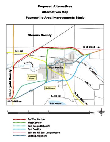
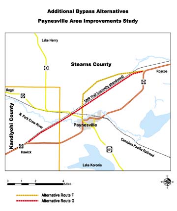
While the traffic counts tell about the total volume of traffic on the road, the origin-destination study, along with demographic and housing information, will be used to determine the local traffic patterns, said Parker. "It's basically to figure out the travel patterns of people in the city of Paynesville and Paynesville Township, so we know what sort of road we need and where to go," he said. For the origin-destination, a sampling of the traffic that stopped in Paynesville was questioned about the place and purpose of their stop. "What we're focusing on is who's stopping in town, because there's a different set of people who travel than those from St. Cloud to Willmar," said Parker. To further determine the local traffic patterns, Edwards and Kelcey has divided the city and the township into six zones apiece. They have also divided the area counties and the state into bigger and bigger zones to study traffic patterns, said Parker. The hope is to use the patterns to decide which potential routes to study and which should be eliminated from consideration. MnDOT must look at not improving the highway at all. The study will also look at improving the existing alignment of the highway as well as several bypass options. Originally, three general bypass ideas were raised: an east bypass, a west bypass, and a far-west bypass. These general ideas have led to seven more specific routes. At a meeting with the advisory technical and local task force committees in mid-March, these possible bypass routes were released. Parker hopes a decision about which possible bypass routes should be studied further - or scoped, in technical jargon - can be made by the committees when they meet this month. The object is to get rid of the ones that aren't going to go anywhere, Parker explained, and study the ones with real possibilities. Proposed Alternatives Map • Additional Bypasses Map The possible routes of Highway 23 (see maps on page 1 and page 3) are as follows (all directions start from west of town): *Use the existing alignment. *East corridor: leave the existing Highway 23 by the golf course; go through the current driving range; cross Highway 55 east of its intersection with Highway 124; turn north, running roughly parallel to Highway 124; use a bridge to cross the railroad; connect with existing Highway 23 before the bridge across the North Fork of the Crow River east of town. *West corridor: follows Highway 23 to the intersection with Highway 55; then heads north with 55 across the Crow River; goes east on 185th Avenue and Co. Rd. 33, linking back to existing road east of town. *West (variation): Instead of following the existing Highway 23 from the west side of town all the way to the intersection with 55, a variation would have the new road a 100 or so yards to the west. Instead of running between Alco, the American Legion and the high school, this variation would run behind these businesses, between them and the airport, then cross the river and follow 185th Street and Co. Rd. 33 back to existing Highway 23. *Roseville Road: leave Highway 23 a couple miles west of town and take Roseville Road to 185th Avenue and Co. Rd. 33, and then back to 23. *DNR trail: this route would follow the old railroad track from Hawick to Roscoe, before linking back to 23. *Zion Township: follows the west bypass to 185th Ave., but then instead of returning to the existing road using Co. Rd. 33 it would cut across Zion Township and connect with the existing road by Roscoe. *Highway 4/Co. Rd. 16: Leave Highway 23 between Hawick and Paynesville; head north and connect with Highway 4 going north; take 4 to Co. Rd. 16 and head east towards Roscoe, linking back to existing 23 by Roscoe. More information about the study of Highway 23 is available online at projects.dot.state.mn.us/edkel/023/. A link is also available at the Press's website, paynesvillearea.com. Anyone wishing to find out more about the Highway 23 study or wanting to get their concern expressed to MnDOT can contact local members of the two advisory committees. "The whole reason behind the task force is to have them be our eyes and ears for the community," said Parker, "and to take the information and get it back out to the public." Members of the technical advisory committee include Angela Marthaler from Stearns County Environmental Services, Stearns County Highway Engineer Mitch Anderson, Lowell Flaten from MnDOT, Joe Voss from the Paynesville Planning Commission, city engineer Pete Carlson, city administrator Steve Helget, and public works director Ron Mergen. Members of the local task force committee are: high school principal John Janotta, county commissioner Don Otte, Mayor Jeff Thompson, council member Dave Peschong, township board chairman Don Pietsch, Paul Evans (representing the Paynesville Area Chamber of Commerce), Peter Jacobson (representing the Koronis Lake Association), township resident Ed Gottwald, and city residents Joe Kremer and Jeff Bertram.
Contact the author at paypress@lkdllink.net • Return to News Menu
Home | Marketplace | Community
|