Task force recommends west bypss to MnDOT
The task force - urged to give their opinions by Lowell Flaten, project manager for MnDOT - did not cast a unanimous vote for the west bypass. Some members said they still felt that either the east bypass or the far west bypass was the best route, but even where someone had another preference, the west bypass was close to the top of their list.
 Consulting engineers Edwards and Kelcey, who are actually completing the EIS, and MnDOT intend to identify a preferred alternative in the draft EIS, due this summer, said engineer Tom Parker, project manager of the Highway 23 study for Edwards and Kelcey. Identifying one route should speed up the process and focus comments and discussion on that route, he said.
While MnDOT officials will ultimately decide on the preferred alternative, they want to know the local preference, said Flaten. "We're at a point where MnDOT is ready to hear what people have to say," he said.
The draft EIS - which should identify a preferred alternative - should be published this summer, according to Flaten and Parker. Copies of the draft EIS will be made available to the public at the local library and city hall. Then, during a comment period, a public hearing will be held in Paynesville, to explain the draft report and take comments.
The discussion of the preferred alternative by task force members - at a meeting on Tuesday, March 2 - followed a presentation on the remaining steps to completing the draft EIS and on the significant issues identified so far.
When Flaten asked for input, task force member Jeff Bertram questioned how much impact that input would have with MnDOT, since the city council's effort to have the far west bypass dropped from consideration was rejected by MnDOT.
Flaten explained that the far west route was kept in the draft EIS because so much work had already been put into it and because the draft was so close to being done, including it. Parker added that including the far west bypass would make the EIS a more complete document when finished, and more defensible to other government agencies.
Before most of the task force members gave their opinions, city council member Dave Peschong pushed Flaten to give them MnDOT's perspective on the routes. Flaten said that the far west bypass, while handling traffic, was difficult to build since the city council has indicated that it would not waive its rights to have Highway 23 touch the city limits. Four lanes through town, the east bypass, and the west bypass would all work in handling traffic, continued Flaten, though the through-town route faces some complications: soil contamination from current and old gas stations and impact to historical sites.
Mayor Jeff Thompson was the first task force member to state an opinion. While he found the far west bypass personally appealing, he said that he was still not inclined to waive the city's right to have the highway touch the city limits, effectively eliminating that option.
Most residents have told Thompson that they want the highway out of town, while business owners have told him to keep the highway close to town, he said.
Relocating 30 homes and businesses, to expand the through-town route to four lanes, was too severe an impact to the city tax base, said Thompson. So he said he could support either the east or west bypass, with his preference being the west bypass since it would not divide the city from Lake Koronis.
Bertram said he had heard many of the same concerns: residents not wanting the congestion in town but businesses wanting the highway traffic close and still accessible.
City council member Harlan Beek, who is not a member of the task force but has regularly attended its meetings, said he has heard many of the same things: residents want the highway out of town, while businesses want it through town or close to town. Since businesses oppose the far west bypass and the east bypass impacts the golf course and divides the city from the lake, that leaves the west bypass as the best alternative, he said.
Peschong said that most city people have told him that they just want a decision and that they consider either the east or west bypasses as the only real options. For the city, Peschong said, the areas east of town seem better for residential development, easier for the extension of city services (water and sewer). In order to keep this area for residential development, Peschong said he prefers the west bypass.
City administrator Steve Helget reported that comments from residents at city hall, which has had maps of the proposed routes for the public to examine, yielded the most negative remarks for the through-town option while the west bypass getting the most positive comments. The far west bypass was next, he said.
The school district prefers the west bypass, said high school principal John Janotta, who is their representative on the task force.
Paynesville Township supervisor Pat Meagher said he still thinks the far west bypass is the best route but added that he thinks the west bypass is next.
Parker, when pressed for an opinion, said that as an Interregional Corridor (handling regional traffic quickly), the far west bypass is best. But this does not take into account local concerns, he added.
Task force member Paul Evans said his personal opinion is that the east bypass is the best route.
Flaten said that MnDOT has heard opinions that the east bypass would be more scenic, running on the ridge south of Paynesville, overlooking the town. (The west or far west bypasses, on the other hand, would run past the city sewer ponds north of town.)
But the east bypass, while giving vehicles a view of Paynesville, would also expose local residents to more noise from all the passing cars, noted Meagher. Plus, it would look like a "concrete fence" between the city and township, said local business owner and township resident Peter Schoell.
While business interests would still like to consider a through-town route, Meagher noted that not only would 30 houses and businesses need to be moved to make room for a four-lane highway, but twice as many residences would then be located next to a four-lane highway. Meagher said he would feel more sorry for homeowners who would end up next to a four-lane, through-town highway than for the homeowners who have their houses purchased by MnDOT and get to move.
Building a four-lane highway through Paynesville faces two unresolved issues: possible soil contamination along the route (up to a dozen current or former gas stations along the route) and possible impact to historical sites. So far, Edwards and Kelcey has identified two historical sites that would be impacted by expanding Highway 23 through town: the Civil War Memorial in the small triangular park across from Grace United Methodist Church, which could be replaced, and at least one historic house on the south side of Highway 23.
Local business owner Dave Lange asked Parker for more specifics about a three-lane through-town option, which could be built on the existing highway surface. While this is OK in the short term in handling traffic, said Parker, by 2025 it does not handle traffic well, indicating a need for a better long-range solution.
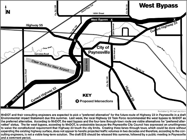
West Bypass
The west bypass, coming from the west into Paynesville, would angle to the north near the Stearns/ Kandiyohi county line and would come to town in the farmland to the south of the new airport. It would turn to the north, around the end of the new airport runway, and run behind the row of businesses along Highway 23 across from the high school. It would run through the runway for the old airport.
It would cross the Crow River and have an interchange with Highway 55 on the north side of the river. To accommodate this interchange, Co. Rd. 130 would need to be rerouted to the west. Then, north of town, the west bypass would run along 185th Street, go past the city sewer ponds, and rejoin the existing highway a mile or so east of Paynesville.
This bypass would have five exits to Paynesville: where it splits, by the high school (now planned with a new city street in the vacant lot between Yarmon Ford and Paynesville Inn and Suites), an interchange with Highway 55, an intersection at Lake Avenue, and where it rejoins Highway 23.
Significant Impacts
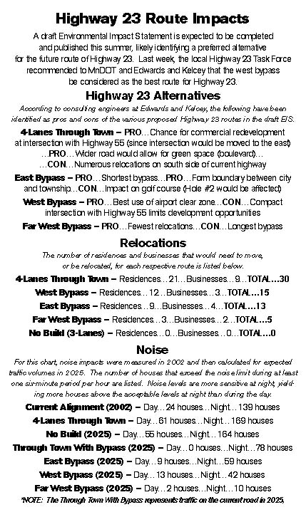
The draft EIS includes social, environmental, and economic impacts of the possible highway routes, said Parker, divided into substantial, moderate, and minimal impact. The bulk of the document focuses on the substantial impacts - economic, farmland, floodplain, noise, pedestrian impact, relocation (of homes and businesses), water quality, and wetlands - said Parker.
Ecomonic impacts are hard to measure, said Paul Baumgartner, another engineer with Edwards and Kelcey, last week. The most impact would be on highway-oriented businesses, though how much is impossible to determine.
Edwards and Kelcey, said Baumgartner, still needs to figure the impact to the city tax base by the number of relocations, 30 in all, by the four-lane through-town option.
Of course, if the project were not actually built until 2017, businesses and residents would have lots of time to plan for highway route change, said Parker. But MnDOT still hopes to get additional funding to accelerate this project. Flaten said MnDOT still hopes to be able to build starting in 2007.
In farmland impact, the three bypass routes are all close, affecting between 250 and 280 acres each.
Each of the bypass routes would also affect the floodplain of the Crow River, since each would require a new bridge (or bridges) over the river. The far west bypass would affect 13 acres of floodplain, the east bypass nine acres, and the west bypass eight acres, said Parker, though these estimates would be reduced once the actual bridge configurations are known.
Noise impacts would be greatest on the through-town routes. To compute the noise impact, Edwards and Kelcey started by measuring the actual noise levels along the current highway in 2002. Then they adjusted that for increased traffic volumes projected for 2025.
Noise levels would affect the most houses on the through-town route. (See graphic above.) The east and west bypasses were next, with the far west bypass affecting the fewest residences.
The through-town route would also impact the most existing homes and businesses, taking a half block to the south of the existing highway and requiring that 30 homes and businesses move, or be relocated. The west bypass would require 15 relocations, the east bypass 13, and the far west only five. (See box.)
Any wetlands affected by a new route for Highway 23 would need to be replaced on a 2:1 basis, Parker said. Five potential mitigation sites have been identified in Paynesvile Township north of the city.
Contact the author at editor@paynesvillepress.com • Return to News Menu
Home | Marketplace | Community