Comment period on environmental review starts for development
A 30-page Environmental Assessment Worksheet was approved by the Paynesville City Council last week and published this week in the official publication of the Environmental Quality Board, the EQB Monitor, which starts a 30-day comment period. That comment period started on Monday, Feb. 27, and ends on Wednesday, March 29.
 The current concept plan for the mixed development calls for 178 single family lots and 56 twin- or four-plex dwelling units, as well as 25 acres of commercial lots and 13 acres of industrial lots.
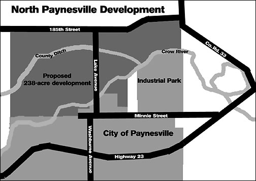
A mandatory Environmental Assessment Worksheet has been prepared for the proposed North Paynesville Development, a 238-acre development by Ferche Development, LLC, on the north side of the city of Paynesville. The comment period on the EAW, which can be viewed at city hall, lasts until Wednesday, March 29.
While the development may start this year, full build-out may not happen for 20 years.
The Environmental Assessment Worksheet for the proposed development was mandatory, engineer Scott Hedlund of SEH, who prepared the document for the developer, Ferche Development, LLC, of Rice, told the city council last week. One trigger that made it mandatory was the number of housing units.
The 35-page Environmental Assessment Worksheet (EAW) includes wetland impact; fish and wildlife impact; erosion; water runoff; physical impacts on water resources; water and sewer use; traffic impacts; archeological impacts; and even odors and dust.
The city's current sewer treatment ponds have sufficient capacity to handle the extra load from the development, but the water use in the development may require another elevated water tank.
The development, according to the EAW, will generate an estimated 13,700 daily trips. This traffic impact is not only estimated on local roads but for parking, too. In contrast with an earlier concept plan, which called for another bridge over the Crow River, making Washburne Avenue extend through the proposed development, the EAW calls for using Lake Avenue as the prime city street through the development. This eliminated having to study the possible impacts of another bridge in the EAW.
Lake Avenue, Hedlund told the council, would probably need upgrades to accommodate the development. Right-hand turnlanes would be a minimum, he said, and left-hand turnlanes would be nice, too, as would eliminating the two 90-degree jogs that Lake Avenue makes as it joins Minnie Street before the railroad tracks and then turns south to go over the tracks and become Washburne Avenue.
The EAW also identified one archeological site in the proposed development that might warrant additional study.
It lists permits that the development would need to get and that mitigation would be needed for wetland, floodplain, and surface water runoff impacts.
The city of Paynesville is the responsible governmental unit for the EAW. Copies of the complete EAW, which are being mailed to a number of governmental agencies, will be available for viewing at city hall during the comment period.
Contact the author at editor@paynesvillepress.com • Return to News Menu
Home | Marketplace | Community