City council continues discussions with MnDOT over airport/highway issue
MnDOT's Office of Aeronautics brought concerns about the proposed Highway 23 running through the clear zone at the end of the runway of the Paynesville Municipal Airport back in November, and the two MnDOT branches (aeronautics and highways) pledged to work together for a solution.
Concerns remained at last week's joint special meeting of the city council, local airport commission, and MnDOT branches.
Aeronautics Concerns
Mike Louis, the zoning administrator and planning director for MnDOT's Office of Aeronautics, said he was concerned about Paynesville's history of not protecting its airport. Paynesville received state funding for its original airport in 1947, said Louis, but by 1951 development was encroaching on its air space. This, ultimately, led to the closing of the airport as a public facility in the early 1980s.
Now, a new public airport has been built, with state funds again, and zoning ordinances enacted to protect its air space.
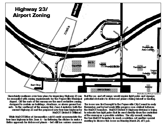
Not only does the proposed four-lane highway run through Zone A, which is meant to be a clear space for emergency landings during takeoffs and landings of planes, but it now includes ramps that require lights and signage, hazards to planes in a supposed clear zone.
"An airplane wing hitting a light standard is worse than a tree," said Louis of the danger. "And gas tanks are in the wing."
Zone A, which lies directly off both ends of the runway, is not supposed to have permanent structures. This is to ensure safety on the ground and the safety of planes in flight, said Louis.
Roads in Zone A are only supposed to be permitted if no practical alternative exists, which he doubted in Paynesville's case since other alternatives for Highway 23 were studied. Still, "We've come to the agreement that we can accommodate the roadway itself," said Louis, though it is not the first choice of aeronautics.
To make for a flatter approach for a disabled plane, MnDOT District 8 has agreed to flatten the slopes of the highway ditches in the airport zoning to a 10-1 slope.
Aeronautics, however, is concerned about light poles and sign poles in Zone A as well as headlight and taillight glare from cars, including from the nearby ramps. Even the ponds for the project are a concern (since ponds attract birds, which are another hazard to planes). Should ponds be located on both sides of the airstrip, said Louis, birds will tend to fly back and forth over the airport, increasing their danger.
MnDOT District 8 has agreed to lower the lights in Zone A and shield them to direct the light to the roadway, not into the air. But two light poles in particular, right down the centerline from the airport, remain a concern for aeronautics.
MnDOT District 8 project manager Lowell Flaten told the city council last week they are still looking at moving these two lights and have sent for information from MnDOT's lighting specialist.
Louis said aeronautics also knows the importance of the highway project and wants to work with MnDOT District 8 to resolve their concerns.
Encroachment on the airport zoning, according to Louis, could jeopardize state funding for the airport (which covers 60 to 70 percent of the costs) and federal funding, for which Paynesville is just becoming eligible (which covers 95 percent of the costs). The Final Environmental Impact Statement for the Highway 23 project is expected to be released within the next month by MnDOT District 8. Unless their concerns are addressed, the Federal Aviation Administration has already indicated that they will want modifications to adequately protect the airport, said Louis.
Louis also expressed concern about the loss of airport property due to the highway project.
Steve Brown, a member of the local airport commission, noted that the loss of airport property limits the amount of total development at the airport - more approaches, more services, and more hangars - not just the runway itself.
"We do have a real asset in that airport, and we need to protect it," said Brown.
Later in the meeting, Mayor Jeff Thompson wondered how the city and MnDOT could work on the highway project for six years, think they finally have a design that was agreeable, and then have such issues.
The original west route used the current highway route, noted Louis, and it gradually crept further and further west, closer and closer to the airport. The proposed four-lane highway is no 700 feet closer to the airport than the current highway.
In defense of the highway department, said Louis, "the devil came in the details, in making that (chosen) alignment work."
Louis also suggested moving the runway to the west to create better protection for the airspace and said the city should have a plan to replace property lost by the airport for the proposed highway plan, which the city is already studying.
Councilor Jeff Bertram said he was puzzled by the concerns of aeronautics, since, he noted, Buffalo and Alexandria have airports with roads close to the runways.
Louis said they had the same level of concerns for these airports, but that the roads might have been there when the airports were built or might have been the only alternative. Having an airport and not protecting it was his concern.
Should the airport not be adequately protected, noted Louis, the state would not help to build another one. "We will not relocate this airport," he said. "We, collectively, need to protect this airport."
Moving the Intersection
If the on and off ramps in Zone A could be moved, said Louis, the needs for lights and signage would be reduced, creating a safer buffer zone for the airport.
They did look at two alternatives for moving the intersection, said Louis, both moving it further south, further out of town.
"I can tell you this much: it's going to move south over my dead body," said Bertram, quickly adding that he had only one vote of five on the city council but had heard no public support for moving this west-end intersection further from town. Louis said he understood the desire to have the intersection closer to the business district but also noted that both aeronautics and the highway divisions had safety concerns.
"I just can't believe that a stoplight at Cemetery Road isn't an option," said Brown, who suggested moving this intersection to Cemetery Road in November. "It would eliminate the land problems; it would eliminate the ramps; it would make everything go away."
Later, Bert Stanley, another member of the airport commission, suggested moving the intersection to the north, to which Flaten responded that it would be too close to the Highway 55 interchange. Stanley then also suggested making the intersection at Cemetery Road at grade (without ramps), and Flaten said that interchanges are safer and that mobility (travel time) was also a factor in MnDOT's preference for an interchange on the west end. "That seems to be the key here ...getting traffic from Willmar to St. Cloud as fast as possible," responded Stanley.
How is four miles of four lanes thru Paynesville benefitting Paynesville? asked Brown.
The hassle of the city, highway, and airport has already started, and the highway hasn't even been built, said local resident Dick Michaelis. Instead of a lifelong conflict between the highway and airport, maybe another plan for the highway should be considered, he suggested.
Though at first he said he was reluctant to revisit the route selection, Bertram later suggested that, in order to get cooperation, Paynesville should consider rejecting the project, so the pressure from Willmar and St. Cloud to complete the project prompts some compromises by MnDOT.
The Minnesota Design Team is visiting Paynesville in April (see separate story on page 1), and one thing that the city wanted from their visit was input about making the community attractive from the new highway. That'll be difficult to do with the highway project in such an uncertain state when the design team comes, said Bertram.
Flaten said the meeting was premature since District 8 had not had a chance to work out the concerns. Moving the intersection, he added, would change land acquisition as well as design and could delay the highway project.
Since the city council met with MnDOT's highway and aeronautics divisions in early November and because he could see little progress since, Bertram said that "the answers, in my mind, have to come sooner rather than later."
When Flaten answered that in a month they would know, Bertram proposed setting another special city council meeting with the MnDOT branches in a month. The city council set that special meeting for Monday, March 26, at 5 p.m.
Contact the author at editor@paynesvillepress.com • Return to Highway 23 page
Home | Marketplace | Community